Official Park Map
Tap either map to view full size. Download the PDF before you go — cell service is nonexistent on the trails.
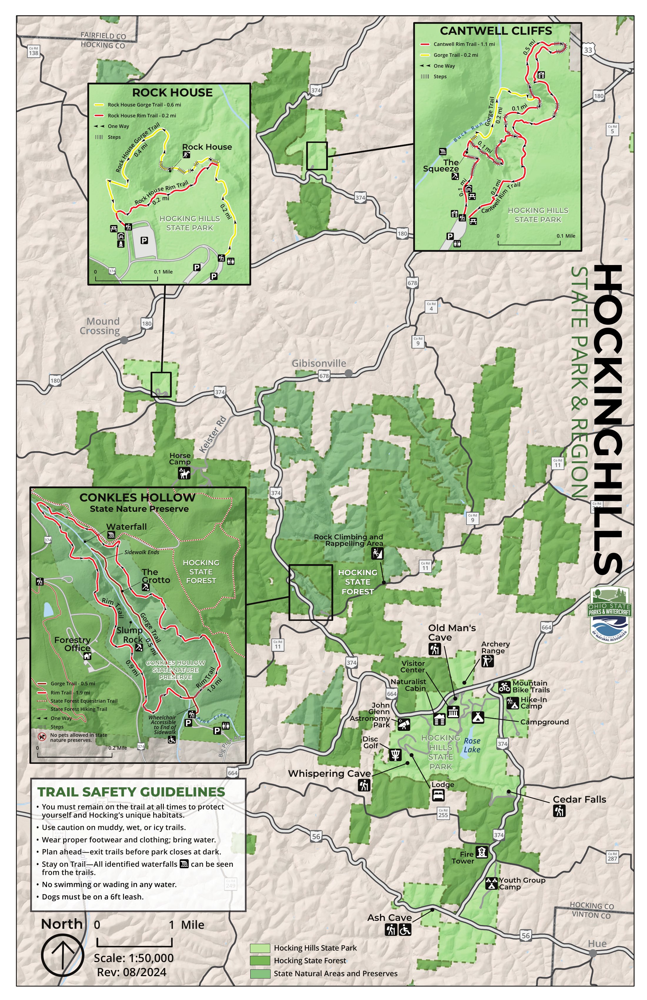
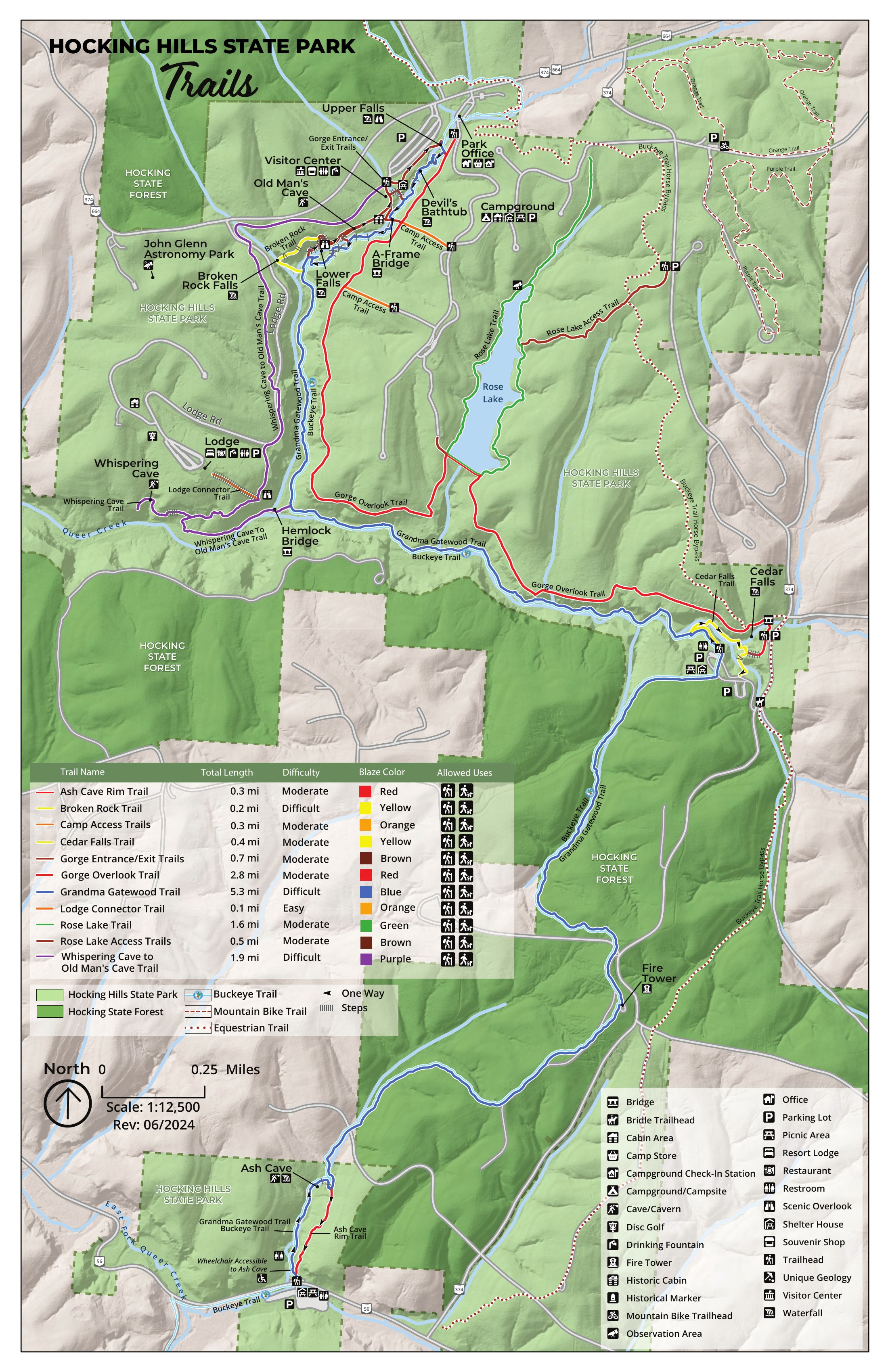
Source: Ohio Department of Natural Resources · Rev. 08/2024
Hocking Hills State Park · 2,356 Acres · 7 Major Trails
Fact-checked trail guides for every major hiking area in Hocking Hills — distances, difficulty ratings, dog policies, seasonal conditions, and what to expect on the trail. Plus 150+ miles of regional trails beyond the park.
All seven major hiking areas — select a trail for the complete guide with distances, elevation, GPS coordinates, and insider tips.
The most popular trail in Hocking Hills State Park and the starting point for the six-mile Grandma Gatewood Trail. Named after Richard Rowe, a hermit who lived in the cave after the Civil War.
View Trail Guide →The easiest and most accessible major trail in Hocking Hills, ending at Ohio's largest recess cave — a natural amphitheater so massive it has served as a shelter for centuries.
View Trail Guide →Cedar Falls produces the greatest volume of water of any waterfall in Hocking County — a 50-foot cascade that's arguably the most photographed in Ohio.
View Trail Guide →Designated a State Nature Preserve in 1977, Conkle's Hollow contains one of the deepest gorges in Ohio — sheer Black Hand sandstone cliffs rising nearly 200 feet.
View Trail Guide →The most remote and most challenging trail in Hocking Hills — and the most rewarding for hikers who want solitude, dramatic geology, and a real workout.
View Trail Guide →The only true cave in Hocking Hills — a 200-foot-long tunnel corridor set midway up a 150-foot sandstone cliff, with Gothic-arch windows framing forest views.
View Trail Guide →The park's newest major trail area and its most acclaimed — USA Today's 10Best ranked Whispering Cave the #1 Best Hiking Trail in America in 2024.
View Trail Guide →The epic six-mile point-to-point trail connecting Old Man's Cave, Cedar Falls, and Ash Cave — named for Emma "Grandma" Gatewood, who in 1955 became the first woman to solo thru-hike the Appalachian Trail at age 67.
View Trail Guide →One of Ohio's darkest skies, a 28-inch observatory telescope, and free guided stargazing programs every clear Friday and Saturday night from March through November. Perseids viewing in August.
View Guide →Tap either map to view full size. Download the PDF before you go — cell service is nonexistent on the trails.
Source: Ohio Department of Natural Resources · Rev. 08/2024
150+ miles of trails in forests, preserves, and parks surrounding Hocking Hills State Park.
59 mi hiking + 40 mi bridle
Surrounding the state park, Hocking State Forest offers 59 miles of hiking across three trail systems, plus 40 miles of bridle trails through rugged terrain.
Learn More →10 trails · ~14 mi
5,470 acres of woodland with sandstone cliffs, ravines, and Ohio's largest state nature preserve. Home to 2,200+ species including Ohio's last rhododendron colonies.
View Trail Guide →17+ mi hiking + 25+ mi mountain biking
Entirely within the 26,824-acre Zaleski State Forest, Lake Hope surrounds a 120-acre C-shaped lake. Seven hiking trails through deep forest.
Learn More →29.1 mi backpack loop + 50+ mi bridle
Ohio's second-largest state forest offers a 29.1-mile backpack trail in three contiguous loops. The popular South Loop covers 10 miles with primitive campsites.
Learn More →Peak mid-October · Best trails for color · Beating the crowds
❄️Frozen waterfalls · Annual Winter Hike · Gear essentials
🌸300+ species · Peak waterfall flow · Best March–June trails
☀️Gorges run 10–15°F cooler · Lake swimming · Clear Creek's 5,470 acres
The gorges, caves, and waterfalls of Hocking Hills exist because of Black Hand sandstone — a coarse-grained formation deposited roughly 340 million years ago when this region lay beneath a vast inland ocean. Ancient rivers flowing from the proto-Appalachian Mountains carried sand into the shallow sea, building up layers over 100 feet thick.
The magic happens in the middle. The sandstone has three distinct layers: a resistant upper cap, a softer porous middle, and a resistant lower base. Water infiltrates the middle layer, dissolves the cementing minerals, and carries away loosened sand grains from the inside out — a process called sapping. Over thousands of years, this creates the massive horizontal recess caves beneath the cap rock. The region was never scoured by glacial ice during the last ice age (the glacial boundary runs just to the north), which is why these formations survived while similar geology elsewhere in Ohio was ground flat.
One more thing worth knowing: the creek flowing through the valley and feeding Cedar Falls is called Queer Creek. The name dates to the early 1800s — settlers found the creek's course geographically unusual, following an unexpected path through the hills. "Queer" simply meant "strange" or "unexpected" in early 19th-century English. The name appears in records as far back as 1834. The last local bison was reportedly killed along its banks in 1799, and the county's first election was held at Eby's mill near the creek.
Find cabins with hot tubs, fire pits, and forest views minutes from every trailhead.
Find Your Cabin →